GIS & Geospatial Applications

We develop Geographic Information Systems (GIS) and spatial data platforms for urban planning, agriculture, and climate management, combining map layers, satellite data, and spatial queries for effective geospatial analytics.

Our geospatial solutions transform complex spatial data into actionable insights for informed decision-making across diverse applications.

GIS Data Platforms

GeoServer & GeoNode systems

Satellite Data Integration

Google Earth Engine solutions

Precision Agriculture

Smart farming applications

Web-Mapping Tools

Spatial visualization platforms

Get Started

Advanced Geospatial Solutions for Smart Decision Making

GIS & Geospatial Applications

Our GIS and geospatial applications harness the power of location intelligence to solve complex spatial challenges. We integrate satellite imagery, sensor data, and advanced analytics to create comprehensive mapping and analysis solutions for urban planning, environmental monitoring, and precision agriculture.

GIS Data Platforms

Comprehensive GeoServer and GeoNode implementations for spatial data management, sharing, and collaborative mapping workflows.

Satellite Data Integration

Google Earth Engine integration for large-scale satellite imagery analysis, environmental monitoring, and change detection applications.

Precision Agriculture Apps

Smart farming solutions like Solorrow for crop monitoring, yield prediction, and resource optimization using geospatial analytics.

Web-Mapping & Visualization

Interactive mapping platforms and spatial visualization tools for data exploration, analysis, and presentation of geospatial insights.

Transform Spatial Data into Strategic Insights

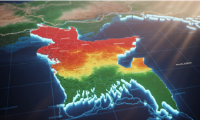
Our GIS and geospatial applications combine cutting-edge mapping technologies with advanced spatial analytics to deliver comprehensive solutions for urban planning, environmental management, and precision agriculture initiatives.

From satellite data integration to interactive web-mapping platforms, our geospatial solutions enable organizations to visualize, analyze, and act upon location-based information with unprecedented accuracy and efficiency.

Get In Touch Now